ADFRibbons

PANDANUS PARK MAPS

Pandanus Map 2014

Copies of this map which has been updated for the 2014 season will be available at Pandanus Park for issue to all new arrivals and those who seek a copy.

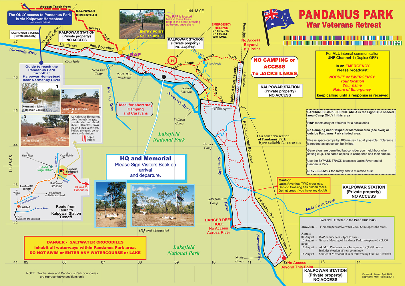
If you are new to Pandanus Park please call on UHF Channel 1 (Duplex OFF) to seek directions. However if there is no response please seek guidance from the first camper you see.

In general the camp areas on the southern or second section of Pandanus are heavily timbered and more difficult to access with almost all unsuited to other than small off-road campers and pop-top vans.


Camps beyond Jacks Creek can only be accessed by 4 WD vehicles with high clearance and no trailers.

The HQ 'building' is approximately 500 metres beyond the Entry Point (near the creek).

EMERGENCY HELIPAD
E144 17.775   S14 56.351   92feet AMSL

NOTE:   Camping is not permitted within 100 metres of the HQ area and the helicopter landing sites.

Headquarters

HQ Building-  Note the Sign-in book is located in the drum on the wooden bench


TRACKS WITHIN PANDANUS PARK

FOR THE CONVENIENCE AND SAFETY OF ALL –  PLEASE DRIVE SLOWLY.

There are few established tracks within Pandanus Park however those that do exist serve us
well hence all traffic is to be confined to these established tracks.
This is a requirement of the Deed of Licence.

DRIVE SLOWLY AT ALL TIMES – THE TRACKS WITHIN PANDANUS PARK BECOME MORE AND MORE DUSTY AS THE SEASON PROGRESSES and VETERANS REGULARLY WALK THE TRACKS SO DRIVE SLOWLY
Even though this private property normal road traffic rules apply and are enforceable.

Note:

The North part of Pandanus (between the red lines) is easily accessible by caravans whereas the Southern half of Pandanus Park has limited access to river front campsites and is unsuited to caravans and in some instances, camper trailers.

Pandanus_Tracks


Northern Sector Tracks

Pandanus_Tracks_-_North_sector

Southern Sector Tracks

Pandanus_Tracks_-_Southern_Sector